Preparing the Learner
Introduce five key terms / concepts for the lesson. State the term and ask students to repeat the term (2 - 3 times). Have students complete the Knowledge Rating to assess if they understand the terms. Students understanding and use of the terms will increase as they use them throughout the unit. A Vocabulary Jigsaw is included to review the terms at the end of the unit.
NOTE: The Knowledge Rating includes cognates. For students whose first language (L1) is not Latin-based, the teacher may choose to provide a translation of the term.)
In the eighteenth-century, "frontier" was defined as a vulnerable, militarized boundary, not an area for expansion (Spero). In Spanish, "frontera" is a term for a national border.
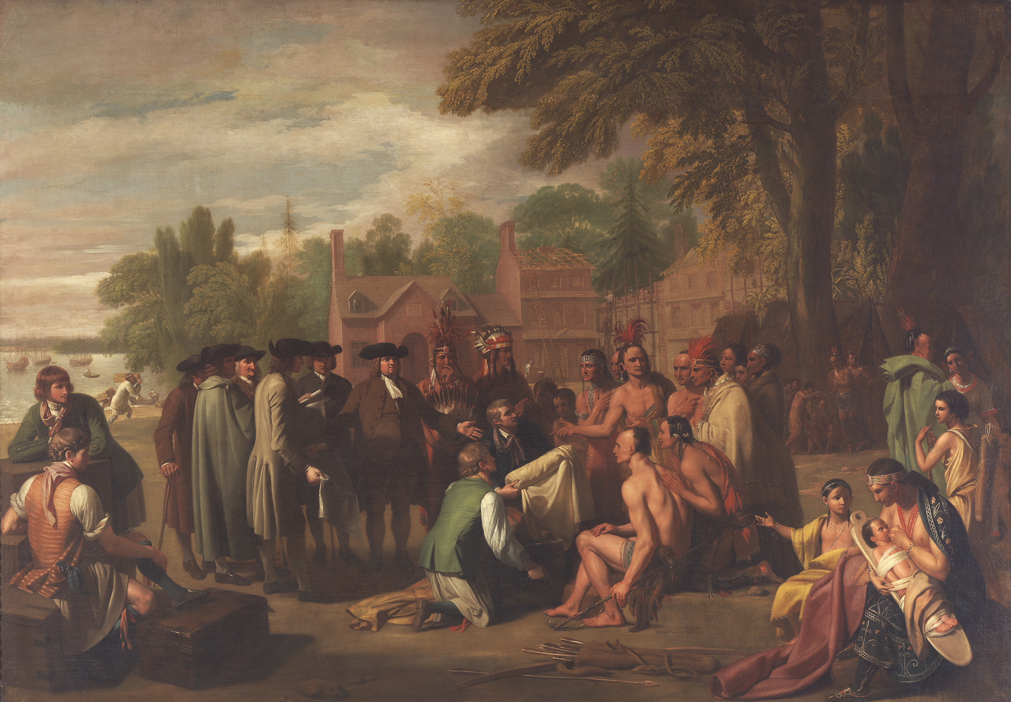
Analyze Benjamin West Painting
- Use the Primary Source Analysis Tool to model analysis of the Benjamin West's Penn's Treaty with the Indians (1771-72).
- Distribute reproductions of the painting and the Primary Source Analysis Tool.
- Have students complete the tool in pairs or triads.
- As a class, share summaries about what they learned from the painting. What is the message? What may be misleading about the paintings? (buildings, clothing, position of people, etc.) Is the painting a primary source document? (No – it's an artist's rendition of an event created nearly 100 years after it occurred and it was commissioned by Penn's son, Thomas Penn.)
- Ask students what the painting tells people about the relationship between European settlers and indigenous peoples?
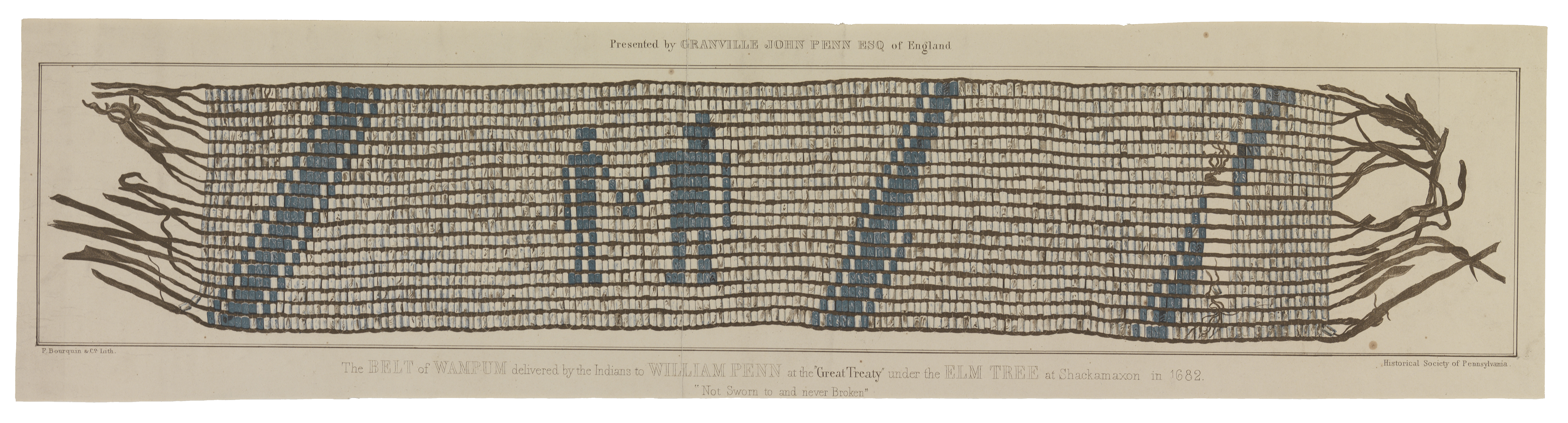
Optional: Project Penn Wampum Belt (1682 Shackamaxon treaty). The belt was given to the Historical Society of Pennsylvania by William Penn's great grandson in 1857. Ask students to consider whether or not it is a primary source and what it might tell us about contact between European settlers and indigenous peoples.
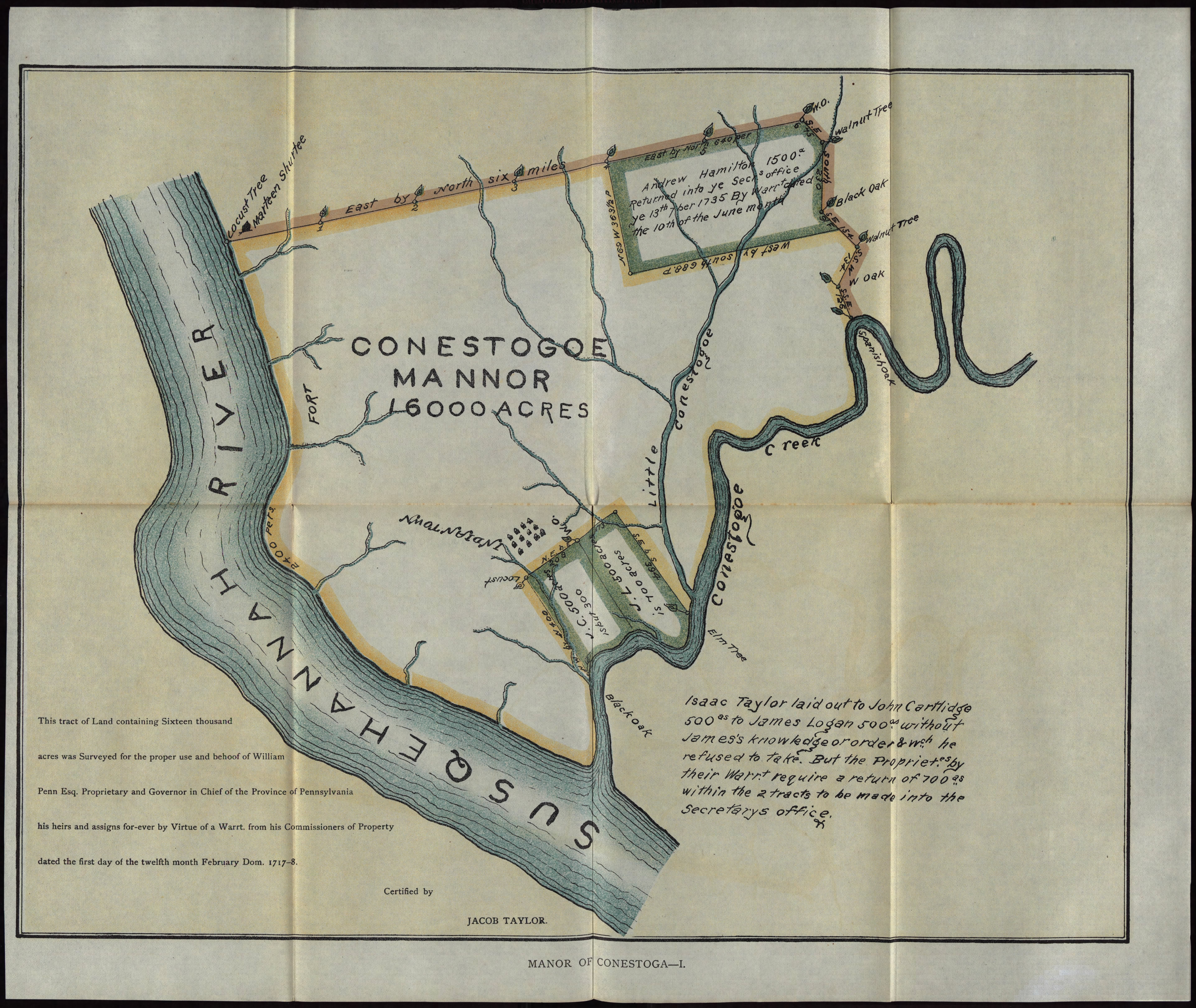
Jigsaw: Analyze historical maps of Philadelphia, Pennsylvania, and Conestoga Manor
- Students will analyze 5 historical maps of Philadelphia, Pennsylvania, and Conestoga to locate the Conestoga Indiantown in relation to Philadelphia, Harrisburg, and the colony of Pennsylvania.
- Model using the Primary Source Analysis Tool to analyze A Map of the Province of Pennsylvania (1756)
- Divide the class into groups of 4 students. This is the "home group."
- Give each member of the "home group" a different map. Tell students they will be responsible for teaching one map to other members of their home group.
- Break into "expert groups." Each member of the "expert group" has the same map. Students should complete the Primary Source Analysis Tool for their map.
- Return to the "Home Group." Each student will report their findings of the map.
- As a class, discuss the summary of their findings about the maps.
Summary Quick Write
Project the Conestoga Indian Town Historical Marker and read the marker text:
About one mile eastwards stood the Conestoga Indian Town. Its peaceful Iroquoian inhabitants were visited by William Penn in 1701 who made treaties with them. In 1763 they were ruthlessly massacred by a frontier mob called the Paxtang Boys.
Students will summarize the historical maker: who, what, where, when.
- Model who (Iroquoian inhabitants, "Paxtang Boys").
- Ask students to find what, where, and when with a partner. (Students may benefit reading the text with the bold, italicized and underlined information.)
- Review the summary.
- Quick Write: What will be read in Ghost River? (In Ghost River, we will read about…)
Think/Write/Pair/Share:
- What did you learn about Pennsylvania, Philadelphia and Conestoga Indiantown based on the information on the maps? (I learned…)
- What is the connection between the paintings, historical marker, and the maps? (The connection is…)
- What did you learn from the historical marker? (We learned…)